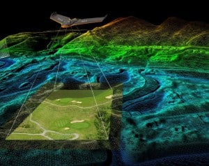
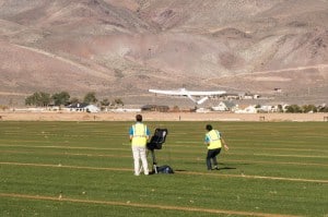
Aerial Mapping
DroneDeploy: Enterprise Grade or Not?
DroneDeploy’s new App Market fills a need for commercial drone use, but can the data quality measure up for widespread industrial use? THE FACTS: This past week, DroneDeploy introduced its new App Market, a store for drone applications from a range of companies—including Autodesk, Box, John Deere, and 13 others—as well as a variety of … Read more
The Truth About Drones in Mapping and Surveying
According to 2015 statistics from the US Department of Labor, there are 44,300 surveyors in the United States. But mapping is practiced by a larger population of cartographers, topographers, photogrammetrists, civil engineers, and geographers – it’s not exclusive to the surveying industry. The American Society of Civil Engineers lists more than 150,000 members in 177 … Read more
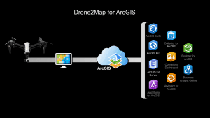
Is Esri’s Drone2Map a Game Changer?
Features should appeal to Esri users, but will they appeal to non-Esri users? THE FACTS: In June 2016, Esri released an application called Drone2Map for ArcGIS. Drone2Map (D2M) takes raw image data from drones and creates digital surface models, orthomosaics, 3D-point clouds and 3D PDFs that can be shared. Data processed by Drone2Map can also … Read more
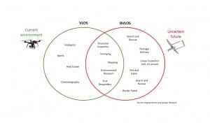
Market Impact of the FAA Small Drone Rule
Barriers to entry are lower, but high margin operations are still restricted. THE FACTS: By now you probably know that the Federal Aviation Administration (FAA) has finally released Part 107, the Small UAS Rule (June 21, 2016), which covers operational use of commercial drones in U.S. airspace. This comes after several years of missed deadlines. You can … Read more

Six Trends Driving the Commercial Drone Market in 2016 and Beyond
“It’s tough to make predictions, especially about the future.” – attributed to Yogi Berra I was recently asked in an interview to discuss four or five trends that I see as major drivers in the commercial drone industry today and what manufacturers and service providers might focus on in the future. That sounds simple enough … Read more

Five Skills You Need to Succeed in the Commercial Drone Market
These days it seems just about anyone can get an FAA Section 333 Exemption that allows them to legally use small unmanned aircraft systems (sUAS) for commercial purposes in the U.S. As of October 20, 2015, almost 71% of all Section 333 grants have gone to firms claiming that their primary operation/mission is Film/Photo/Video (and … Read more

FAA Proposed Drone Rules: Market Opportunity Winners and Losers
On February 15, 2015, the commercial drone industry breathed a collective sigh of relief. The Federal Aviation Administration’s proposed new rules for small unmanned aircraft systems seemed, at first blush, somewhat practical. The FAA regulations will eventually allow commercial operations of drones that weigh under 55 pounds in U.S. airspace, without requiring operators to acquire … Read more
Commercial Drone Markets: 2014 Year in Review
Judging by the headlines, 2014 turned out to be the year for drones. I referenced in Tweets a total of 503 articles with the word ‘drones’ in the headline last year. A Google search brings up about 61.4 million results referring to ‘drones.’ Granted, that search includes references to military and hobby drones, but it … Read more
GIS: The Biggest Little Drone Market in the World
Last week I had the pleasure of participating in a two-day symposium on unmanned aircraft systems (UAS) hosted by the Northern California American Society for Photogrammetry and Remote Sensing (ASPRS). The event was held in Reno, Nevada, (otherwise known as “The Biggest Little City in the World”), and its purpose was to assemble UAS experts … Read more